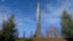
A view of the war memorial monument commemorating the events of WWII located in Žužemberk, Slovenia.
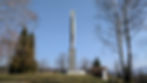
A view of the war memorial monument commemorating the events of WWII located in Žužemberk, Slovenia.
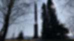
A view of the war memorial monument commemorating the events of WWII located in Žužemberk, Slovenia.
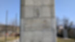
A view of the war memorial monument commemorating the events of WWII located in Žužemberk, Slovenia.
Žužemberk
Brief Details:
Name: 'Monument on Cvibelj Hill' or 'Monument to the Liberation War in Žužemberk'
Location: On Cvibelj Hill in Žužemberk, Slovenia
Year completed: 1961
Designer: Marjan Tepina
Coordinates: N45°50'09.7", E14°55'54.3" (click for map)
Dimensions: 25m tall monument
Materials used: Poured concrete, rebar, marble blocks and aluminum panels
Condition: Excellent
(ZHU-zhem-berk)
History:
The monument at the spomenik complex in Žužemberk, Slovenia commemorates the fallen Partisans who perished fighting in the Suha Krajina district during the National Liberation War (WWII).
World War II
When Slovenia was invaded by Axis forces in April of 1941, the entire town of Žužemberk (located in the Suha Krajina (Dry Carniola) region) was besieged and annexed by an occupation force of Italian soldiers. The Italian military command stationed their regional headquarters at the town's historic Žužemberk Castle. As the end of 1941 approached, Slovenes in Žužemberk (and across Slovenia) began to organize themselves into armed resistance groups in an effort to defend against and drive out occupying forces. Calling themselves the Slovene Partisans, organized by the anti-fascist Liberation Front (OF) political group, these resistance fighters initially operated in crude guerilla units, however, during 1942, they became more organized and began operating as a coordinated fighting force. While the Slovene Partisans predominately fought against Italian Axis forces across the Suha Krajina region, they also engaged against some Slovene Catholic activists, whom Partisans felt were collaborating and aiding Italian forces. These Catholics eventually formed anti-communist militias, with fighting between the two groups resulting in thousands of deaths on both sides. The Italian attacks upon the Slovene Partisans were relentless, which went as far as even dropping bombs on them from Italian fighter plans when they attempted to operate in or near Žužemberk. Sources report that the main square of Žužemberk was bombed nearly 30 times (demolishing more than 1/4 of it). However, when Italy capitulated in 1943, Italian forces left Žužemberk, but they were soon replaced with an occupation of German troops. s

Photo 1: Balkan Air Force dropping bombs over Žužemberk, 1944
In 1944, Tito's Partisans began to breakthrough into Žužemberk's Lower Carniola region, which allowed for greater cooperation and coordination between the Slovene Partisans (who until then had been fighting autonomously) and the greater Partisan movement across the rest of the Yugoslav region. Allied bombing missions across Slovenia began in early 1944 which targeted specifically Nazi strongholds in the Lower Carniola region. In early February of 1944, Axis positions across Žužemberk were hit by these bombing missions, most notably Žužemberk Castle (where the German supporting Slovene Home Guard had established a base). The castle was heavily damaged but not fully destroyed. Žužemberk was finally liberated from German control when rocket and cannon shells from planes of the Balkan Air Force surprised German and Slovene forces on February 13th of 1945 (Photo 1), which then allowed Yugoslav Partisan ground troops to take the city. Small skirmishes continued between German fighters and the Partisans, but by May of 1945, the Germans and the Slovene Home Guard had been completely driven from the area. During the course of the war, hundreds of the town's civilians and much of Žužemberk was left in ruins. Furthermore, reports also indicate that over 1,000 local Partisan soldiers were killed.
As a historical aside, it is interesting to note that the famous image of the dramatic rocket attack on Žužemberk Castle seen in Photo 1 is asserted by some sources to be the very first air rocket attack ever photographed. A fascinating story of how this photo was taken can be seen in this short video on YouTube.
Spomenik Construction
In the late 1950s, local government and veteran groups (with aide from the Yugoslav government) organized plans to creating a commemorative spomenik complex in a forested park on the outskirts of Žužemberk on Cvibelj Hill. Notable Slovenian designer Marjan Tepina was granted the commission to create the complex. The complex was officially unveiled to the public in February of 1961 during a grand commemorative ceremony (Photo 2).

Photo 2: A photo of the unveiling ceremony for the Žužemberk monument in Feburary of 1961
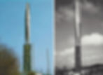
The primary element of the spomenik is a 16m tall aluminum tri-point obelisk standing on top of a 10m tall pedestal. In a crypt underneath the site is interred the remains of somewhere around 1,000 of the Slovene Partisans who fought across the Suha Krajina and for the liberation of Žužemberk, with the names of those interred inscribed on stone panels next to the monument spire. However, it is important to point out that not all of the victims listed on the plaques are actually interred in the tomb, as some families were granted the request to take the remains of their loved ones to be buried in their home towns. When this memorial was built, it was (and still is) the largest Partisan tomb in Slovenia. Originally, the monument's pedestal was polished black granite and much thinner, having the name of the fallen Partisans engraved directly on it. However, in 1988 the complex was renovated, with the pedestal widened and the engraved names being moved to inscribed standing stone panels adjacent to the monument.
Present-Day
The memorial complex here at Žužemberk currently exists in excellent shape, having very well maintained grounds and exhibiting few visible signs of any damage or neglect. It appears that local visitors patronize this site regularly (as many flowers and wreaths can be found left here in tribute). In fact, many in the local community are even still working towards researching local Partisan soldiers from WWII whose names have not yet been included on the site's engraved panel. Meanwhile, the site continues to host a number of annual commemorative and remembrance events. Ceremonial events at the monument often take place around October 25th, which is Sovereignty Day in Slovenia (which celebrates the day that the last Yugoslav Army soldiers left the country in 1991). In fact, ceremonial events at this site are so significant that in October of 2015, the President of Slovenia Borut Pahor attended an event at the monument, while in October of 2018, the Slovenian Prime Minister Marjan Šarec paid tribute during a ceremony at the site.

Photo 3: The English bomb found at Cvibelj Hill in 2016
Interestingly, local reports indicate that in November of 2016 during an excavation of the hillside just a few dozen meters away from the central memorial sculpture at Cvibelj Hill Park, a WWII-era unexploded 250kg English aircraft bomb (containing about 70kg of explosives) was found buried in the ground (Photo 3). A unit from the Slovenian Military's Civil Protection came to retrieve the ordnance to dispose of it properly.
Plaques, Engravings and Graffiti:
There are a number of engraved and inscribed elements at the monument complex here at Žužemberk. Firstly, on the west-facing side of the granite pedestal, there is a large engraving done directly onto the stone blocks (Slides 1 & 2). It reads as, roughly translated from Slovenian to English:
"During the National Liberation War, in battle against occupiers & domestic traitors, across the Suha Krajina, fell 1,144 Partisans and supporters who fought with the Liberation Front. We honor them."
In addition, there are nine standing stone blocks on the south side of the monument (Slide 3) engraved with the names of those 1,144 fallen soldiers.

Slideshow
It is important to note that the thick triangular block pedestal and 9 standing black stone blocks are not original to the monument. They were added in a 1988 restoration. Originally, the pedestal was much thinner and had all of the names of the fallen fighters engraved directly onto it (see Slide 4). The 1988 restoration made the pedestal thicker and changed the location of the engraved names from the pedestal itself to those 9 standing stone blocks. Finally, there is an small discreet engraving at the base of the pedestal which relates the construction date and the renovation date of this memorial (Slide 5). It translates from Slovenian to English as:
Raised: 1961
Updated: 1988
As far as graffiti goes, there was none present or visible at the site upon my most recent visit. Furthermore, I have seen no photos from recent decades of the site that show any graffiti anywhere around the monument.
Symbolism:
The exact intended representational meaning, if any, of the memorial sculpture here at Žužemberk, created by Marjan Tepina, is not immediately apparent upon a first viewing. It is possible that this sculpture is a work of pure abstract sculpture, possessing no specific or overt symbolic meaning. Yet, examining the form of the sculpture in closer detail, one begins to notice the very dramatic play of light on the polished metal skin of the structure, while the three points on the spire's apex reach towards the sky in what appears to be a very deliberate and jubilant expression of symbolism. These qualities of the sculpture very successfully communicate an overall atmosphere of spiritual exaltation, as if this monument perched here atop Cvibelj Hill, visible across the whole valley, is broadcasting the victory won by those who are buried beneath it, almost like a shining reflective beacon (Photo 4). Many WWII monument across the former Yugoslavia use polished metal in their sculptural forms as a symbolic gesture of 'reflection' and the concept of radiating light from a place where there was once darkness. In a 2007 article by historian Jože Škufca, the symbolism of the Cvibelj Hill monument is described as follows (translated into English):
Photo 4: The monument on Cvibelj Hill looking over the countryside
"This magnificent memorial, placed in memory of the victims of freedom, with its monumentality dominates the entire upper Krka valley, and any man who ascends to it has raised within him feelings of respect and greatness. It is surrounded by silence, peace and memories. It warns of the horrors of the war. With its slim shape and upwards-pointing figure, it symbolizes the inner light that has called the people to rebellion, handing it over to revolutionary rapture and flight. It is there to remind us of the toughest and most famous days of our history."
Status and Condition:
At present, the WWII spomenik complex here at Žužemberk is kept in very good shape. Firstly, the grounds and landscaping around the memorial are well maintained and kept adequately manicured, without any overgrown or out of control vegetation. Meanwhile, the structural condition of the memorial itself appears in very good condition, with it plainly visible that the monument's facade is regularly cleaned and repaired. No elements of the memorial site bore any graffiti or vandalism, while the grounds were free of trash and debris. Additionally, it is important to note that this site went through a major redevelopment phase in 1988. During this renovation, the monument's original pedestal, which was much thinner and composed of a black marble engraved with hundreds of names (seen in Slide 1 of the Historic Images section), was replaced with a much thicker and simpler pedestal made of grey stone panels, bearing only one simple inscription on its front face. The engraved list of fallen fighters was moved to 9 tall standing stone panels arranged in a row located directly adjacent to the monument.

Photo 5: Slovenian Prime Minister Marjan Šarec at 2018 ceremony
While there are no multi-lingual interpretive signs at this locations, the engraved Slovenian inscriptions on the monument itself are clearly legible and relate the site's historic importance and history. However, directional signage to this memorial was minimal, to say the least, and I was not able to determine to what degree, if any, this site is promoted by the local municipality of Žužemberk as a regional tourist attraction or local point of interest. While I did not encounter any other individuals visiting this memorial on Cvibelj Hill upon my most recent visit, I did find many sets of honorific candles, wreaths and flowers left here, indicating that the site is still very much respected by the local community. Meanwhile, I found multiple sources which indicate that numerous commemorative and remembrance events continue to be annually held at this site (Photo 5). Finally, there is a large excavated area of earth on the slope just downhill of the spomenik complex to the north which has existed in this state for the last few years. While it is not disturbing or impeding on the memorial complex itself, it is extremely close to it. The purpose of this construction work is not immediately clear and does not seem to be directly related to the complex itself.
Additional Sites in the Žužemberk Area:
This section explores additional Yugoslav-era historical, cultural and memorial sites in and around the greater Žužemberk region that might be of interest to those studying the monuments of the former Yugoslavia. The sites examined here will be the Žužemberk Castle, the Kočevski Rog "Baza 20" Slovenian Partisan headquarters and hospitals, as well as the Oath Monument at Plešivica pri Žalni.
Žužemberk Castle:
As the Žužemberk Castle plays an integral role in the town's WWII history, as well as being pivotal to the cultural history of the town as a whole, it seems necessary to give a brief description and exploration of the castle's story. Situated on a sharp bluff overlooking the beautiful Krka River, Žužemberk Castle is often regarded as one of the most picturesque castles in Slovenia. The first fortifications at this site are believed to have been created around the year 1000. A castle-like structure was first built on the rock terrace in the 1200s, at which point Žužemberk was officially mentioned in writing for the first time in documents recording the castle being sold to Count Albert I of Gorizia. However, when the lineage of the Gorizia noble family ended it the 1300s, the castle was taken over by Ulrich II who was the Count of Celje. When Ulrich died childless in 1456, the castle passed into the ownership of the House of Hapsburg. In 1538, the property was converted into a landowner estate as the Hapsburg king Ferdinand I, Holy Roman Emperor sold the castle to Auersperg family of Turjak. The castle would then stay within the ownership of the Auersperg family for the next 400 years.
It was during these following 400 years that the castle began to take the shape that we recognize today, with the construction of additional towers and fortifications. An interesting often-told tale from the castle's medieval history is that in 1575, a bear wandered into the castle's courtyard and killed King Ivan Auersperg's wife, Ana von Eck. In tribute, he planted a Linden tree in the courtyard at spot where she was killed. The tree survived for 424 years when it was ultimately cut down in 1999 as it began to finally decay. Towards the end of the 1800s, the court of Auersperg slowly began to withdraw from the castle, resulting in its slow decline. In 1893, its last family member Count Karl Auersperg moved out of Žužemberk Castle to the nearby Soteska Castle. After this point the castle sat vacant and unused for several decades until WWII.
.jpg)
Photo 6: A series of mages of Žužemberk Castle between the 1600s and present-day
After Žužemberk Castle was devastated and left in ruins after WWII, but restoration projects slowly began in the 1960s. By the 1990s, rehabilitation was well underway and the shape of the castle was again well recognizable at the start of the 2000s. Today, the castle is in excellent condition but still undergoing continual improvement and restoration. It is open to the public and free to visit. It hosts annual Medieval Days celebrations and cultural events on July 15th. For more information, you can visit the castle's official website here. The exact coordinates for Žužemberk Castle are N45°49'49.6", E14°55'44.7".
"Baza 20" Partisan HQ:
Roughly 20km south of Žužemberk in the remote forested karst plateau of Kočevski Rog is the location where the Slovene Partisan leadership built their operational command base during WWII in the spring of 1943. This particular base was given the code-name 'Baza 20' (Photo 7). This forest had been a refuge and hotbed for Partisan resistance since 1941, but after the Italian's deadly 1942 Rog Offensive that swept the region, other locations became too exposed for the Partisans, so it was decided the remote and inaccessible forests of Kočevski Rog were the perfect location to establish a new base. From Baza 20, the Slovene Communist Party leadership established their headquarters, while it was also the site which the Slovene Partisan command used to conduct operations throughout the region. Several additional bases existed around Kočevski Rog, such as Baza 15, 21 and 80, among others, but Baza 20 was the only base to be preserved after the war.

Photo 7: A present-day image of the Baza 20 Slovene Partisan HQ historical site [Photo from Dolenjski muzej]

Photo 8: Partisan fighters being treated at Jelendol Hospital, 1944
Baza 20 contained everything the Partisans needed to be self-sufficient, such as kitchens, munitions manufacture, printing facilities, workshops, dorms, power production, schools, etc. These facilities were housed in small wooden shacks clustered the dense forest's steep ravines and gullies, which provided better cover and protection from being discovered by the enemy. A map of the Baza 20 complex can be found at THIS link. In addition to the above-mentioned facilities, a number of significant hospital complexes were created, notably Jelendol (Photo 8) and Zgornji Hrastnik. By the fall of 1944, nearly 180 people were being housed at the base. The Partisan and Communist Party leadership operated at Baza 20 until December of 1944, at which point a new headquarters was established in the nearby town of Črnomelj. Throughout the entirety of WWII, the Baza 20 Partisan compound was never discovered. Many civilians were saved by taking refuge at Baza 20 during WWII, and its hospitals treated and saved the lives of thousands of Partisan soldiers. However, in the months after WWII, the forests of Kočevski Rog saw a great deal of death as well, as the victorious Yugoslav forces used the forest's deep karst pits for the mass executions of Axis collaborators.
After WWII, Baza 20 and the Jelendol and Zgornji Hrastnik hospitals were all converted into historical sites open to tourists, adminsitered by the Dolenjska Museum in nearby Novo Mesto. The base is notable in the fact that it is the "only such headquarters of a European resistance movement which is still preserved", continuing to this day as a popular historical attraction in Slovenia (even after the Yugoslav era) and was declared a protected cultural monument in 1952. The exact coordinates for the main entrance to the Baza 20 complex and the Lukov Dom visitor center are N45°41'50.0", E15°02'58.0". The coordinates for the Zgornji Hrastnik Hospital complex (2.5km south of Baza 20) are N45°40'38.3", E15°03'30.3", while the coordinates for the Jelendol Hospital complex (1.5km northwest of Baza 20) are N45°42'23.4", E15°02'00.4". There are also hiking trails to access both hospital complexes from the Lukov Dom visitor center.
Oath Monument at Plešivica pri Žalni:
Roughly 20km west of Žužemberk near the village of Plešivica pri Žalni is a small unique monument in the shape of a hand (Photo 9). This monument marks the location where two units of the National Security (Narodna zaščita) defense force were sworn into their duties on May 28th, 1942, whose primary tasks were to perform background and supplementary duties for the Slovene Partisans. This memorial sculpture's shape is meant to depict the hand sign a soldier would make while giving their oath to be sworn into their military position. The monument was unveiled on May 28th, 1977, celebrating 35 years since the swearing-in ceremony, and was created by Slovene architect Janez Lužar. A metal plaque at the base of the monument reads (translated into English): "Notable people and surrounding villagers were here on May 28th, 1942 when the Liberation Front swore in and established two National Security units. The Union of Fighters and the local community of Žalna." The coordinates for the monument are N45°55'33.9", E14°42'45.7".

Photo 9: A photo of the monument at Plešivica pri Žalni [photo by Marko Krojac]
One curious aspect of this monument is that the three finger oath in which it depicts is a symbol which is often directly associated with the Serbian people, or, as political scientist Anamaria Dutceac Segeste notes, "...the salute remains a distinctive sign for the ethnic Serb and a symbol for belonging to the Serbian nation". For instance, in 2017 a memorial sculpture to Bosnia War victims was built in Zvornik, BiH by the ethnic-Serb community there in a very similar style to this one. From this perspective, its presence here in Slovenia seems potentially a bit unusual. Perhaps the Slovene Partisans borrowed this symbol for their oath ceremonies, but I was unable to find any sources which indicated this. If anyone from the region has further insights as to the symbolic or historical significance behind the usage of this hand-oath gesture in this monument's design, please contact me.
The Škrilj Underground Nuclear Bunker:
Roughly 40km south of Žužemberk in the Kočevje region is a decommissioned underground nuclear bunker known as "Škrilj" (Photo 10), buried into the hillside within the grounds of a military base above the village of Kočevska Reka. The Yugoslav military constructed the facility between 1953 and 1957 as part of an effort to provide top-level officials in the government a place to hold out during a nuclear attack on the country, created in the same vein as the more well-known underground nuclear bunker at Konjic, BiH. Dug down over 80m below the surface, the Škrilj Bunker,also known by the code-name of "K-35", was laid out over an area of 800 sq m, containing about 600m of corridors and six large chambers, all enough for 30 people to survive roughly 100 days without contact from the outside world. This was the most significant complex of its type in Slovenia, while also being among the most top-secret and protected locations within Yugoslavia. During his time as leader, Tito is said to have visited the Škrilj Bunker twice.

Photo 10: A photo of the Bunker Škrilj in Slovenia near Kočevje [source]
After the Yugoslav-era, the importance and critical nature of the Škrilj Bunker was greatly diminished, all while rumors of the existence of the secret base began to spread around the Kočevje region. By the 2010s, its existence was an open secret, so, the Slovenian government began to entertain the idea of turning the now-defunct bunker (still in a preserved un-used pristine condition) into a tourist attraction. As such, in 2017, the Škrilj Bunker began to offer tours of the facility, although under strictly controlled conditions, as the bunker was still upon an active military base. The facility operates as a unique time capsule to the Yugoslav-era and to the region's military history of Cold War preparation and readiness. Škrilj Bunker continues to offer tours up to the present day, although only through reservations which must be made at least two days in advance. Bookings can be made by phone +386 (0) 59 959 204 or via e-mail at bunker.skrilj@kocevsko.com. See the official tour website for the Škrilj Bunker HERE. The exact coordinates for the meeting point and information center for the bunker's tours are N45°34'29.1" E14°48'09.6".
And Additional Sites of Interest:
-
Dolenjska Museum: Roughly 24km east of Žužemberk is the Dolenjska Museum, also known as the Lower Carniola Museum, located in nearby Novo Mesto. This museum has a wide range of exhibits that explore the long-reaching history of this region, which includes a significant amount of material about the area's WWII history. The museum's official website can be found at THIS link, while its exact location is N45°48'11.1", E15°10'05.0".
Directions:
Getting to the monument here at Cvibelj Hill in Žužemberk is a relatively easy endeavor. From the town center of Žužemberk, take Road 650 northeast in the direction of Dobrava. Just as you are about to exit the town limits of Žužemberk, you will see a small unmarked paved road on the left (view on Google StreetView). Follow this road west up the hill for about 300m and you will notice to spomenik up on top of the hill on your left. Once the spomenik is in view, you will then approach a gravel parking lot on the left where you can park (view on Google StreetView). From here you can easily walk to the spomenik. The exact coordinates for parking are N45°50'13.4", E14°55'53.7".

Click to open in Google Maps in new window
Historical Images:

Slideshow
Selected Sources and More Information:
-Spomeniki blog: "ŽUŽEMBERK - Monument NOB"
-Slovenia.info article: "Spomenik NOB na Cviblju"
-Simon Parry book: "Beaufighter"
-Slovenian Ministry of Culture entry: "Žužemberk - Spomenik NOB na Cviblju"
-Lokalno article: "Cvibelj: Spomenik časti in spomina potreben popravkov"
-Poti Suhokranjske article: "70. letnica bombardiranj Žužemberka" (page 42) [PDF]
Comments:
Please feel free to leave a message if you have any comments, if you have any questions, if you have corrections or if you have any additional information or insight you feel might be appropriate or pertinent to this spomenik's profile page.